🔥 ICGSKI 2026将于12月11-13日在武汉召开,诚邀广大学者尽早报名!组委会将在1-3个工作日内回复确认。
🔥 截稿日期:2026年10月15日(版面有限,额满即止);投稿咨询与材料确认:通常1—3个工作日;论文评审和录用通知按审稿流程办理。
🔥 拟安排出版:Proceedings of SPIE—The International Society for Optical Engineering(以最终正式出版信息为准)。
🔥 计划提交检索:EI Compendex | Scopus 等数据库;具体以出版后数据库实际收录为准。
会议介绍 / Conference Overview
ICGSKI 2026,即 14th Annual International Conference on Geo-Spatial Knowledge and Intelligence,第十四届地理空间知识与智能国际会议(ICGSKI 2026)定于2026年12月11—13日在中国武汉举行。会议围绕智慧城市、遥感与GIS、空间数据获取、生态环境数据管理、地理空间建模分析和资源管理等方向,面向研究人员、工程技术人员、高校师生及产业实践者征集原创成果。以地理空间知识与智能为核心,推动遥感、地理信息系统、时空数据处理与人工智能技术在资源管理和可持续生态系统中的研究与应用。
会议旨在汇集全球相关领域的研究者、工程师、大学教师和学生,讨论空间信息获取、处理与管理、建模分析以及智慧城市和生态环境等领域的新问题与新进展。大会特别强调跨学科研究成果交流,包括传感器网络、环境与生态数据、地理空间统计、时空大数据、地理信息服务、数字化可视化、城市规划和灾害风险管理等。
作为学术交流平台,会议鼓励参会者分享原创研究成果和实际项目经验,通过主旨报告、口头报告、海报展示及现场学术交流探讨地理空间智能技术在自然资源管理和可持续发展中的创新应用。
重要日期 / Important Dates
| 重要事项 | 会议安排 | 说明 |
|---|---|---|
| 投稿截止 / Submission Deadline | 2026年10月15日 | 第一卷截稿;如征稿安排调整,将另行发布通知 |
| 录用通知 / Acceptance Notification | 2-7个工作日 | 论文评审完成后,通常2—7个工作日反馈处理结果;具体以审稿进度为准 |
| 注册截止 / Registration Deadline | 2026年12月08日 | 具体注册资格及支付方式以组委会回复为准 |
| 会议日期 / Conference Dates | 2026年12月11—13日 | 中国湖北武汉 |
出版与检索 / Publication and Indexing
本届会议实行学术同行评审制度。稿件经初步审核后,将由2—3位相关领域专家进行双盲评审,综合考察研究原创性、学术质量、方法有效性和论文表达。通过评审的论文将进入后续论文集出版流程。ICGSKI 2026 拟将录用论文提交至 Proceedings of SPIE—The International Society for Optical Engineering(ISSN: 0277-786X)出版;最终以出版社确认和实际见刊信息为准。
会议论文集出版后,计划按相关机构要求提交至 EI Compendex、Scopus、CPCI 等数据库评审,并面向 CNKI、Google Scholar 等学术检索平台。投稿录用、论文集出版和数据库检索为不同环节,具体收录由相应数据库或平台独立决定,任何论文均不能仅凭录用通知保证检索结果。
往届 SPIE 出版信息
2025年(第13届 GSKI 2025)论文集由 Proceedings of SPIE 出版。
往届论文集链接:SPIE Digital Library · Proceedings Volume 14137。
2025届论文集列入往届 EI Compendex 收录记录。有关检索截图将在“往届 EI 检索信息”栏目陆续更新。
优秀论文的进一步投稿渠道
经充分扩展的优秀论文可考虑进一步向 Global and Planetary Change、International Journal of Earth Sciences、Earth Science Informatics 等相关SCI期刊推荐投稿。期刊审稿、录用及收录由各期刊独立决定,推荐投稿不代表保证录用。
历届会议与出版记录 / Conference History
大会自2013年相关系列会议举办以来,持续开展地理空间信息与智能领域的学术交流。历届会议的出版及检索记录如下,具体收录情况可通过相应出版平台与检索数据库核验。往届收录情况不代表本届论文必然获得相同检索结果。
| 年份 / 届次 | 会议举办、论文集及检索情况 |
|---|---|
| 2013 · GRMSE 首届 | 武汉举办;论文集出版于 Springer Communications in Computer and Information Science(CCIS)系列,ISSN 1865-0929,ISBN 978-3-642-41907-2;列入往届EI收录记录。 |
| 2014 · GRMSE 第二届 | 在美国举办;论文集出版于 Springer CCIS 系列(ISSN 1865-0929);列入往届EI收录记录。 |
| 2015 · GRMSE 第三届 | 武汉举办;论文集出版于 Springer CCIS 系列,ISBN 978-3-662-49154-6;列入往届EI收录记录。 |
| 2016 · GRMSE 第四届 | 中国香港举办;论文集出版于 Springer CCIS 系列,ISBN 978-981-10-3965-2;列入往届EI收录记录。 |
| 2017 · GSKI 第五届 | 会议由 GRMSE 更名为 Geo-Spatial Knowledge and Intelligence(GSKI);论文集出版于 Springer CCIS 系列,ISBN 978-981-13-0892-5;列入往届EI收录记录。 |
| 2018 · GSKI 第六届 | 论文集出版于 IOP Earth and Environmental Science(EES)系列,ISSN 1755-1315,Vol. 234;列入往届EI收录记录。 |
| 2019 · GSKI 第七届 | 论文集出版于 IOP EES 系列,ISSN 1755-1315,Vol. 428;列入往届EI收录记录,并提供在线出版链接。 |
| 2020 · GSKI 第八届 | 会议论文集由 IOP 出版,列入往届EI收录记录。 |
| 2021—2024 · GSKI 历届 | 2021、2022、2023、2024届会议均已举办;该阶段未安排独立的会议论文集,部分论文在SCI期刊发表。 |
| 2025 · GSKI 第十三届 | 论文集由 Proceedings of SPIE 出版,Volume 14137,并列入往届EI Compendex收录记录。 |
往届 EI 检索信息 / EI Compendex Records
历届 ICGSKI相关会议集曾通过 Springer CCIS、IOP EES、Proceedings of SPIE 等渠道出版,其中部分届次已列入 EI Compendex 检索记录。
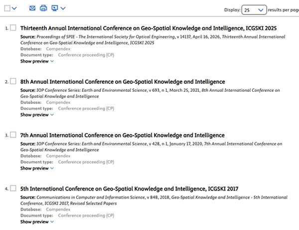 。
。上述信息用于介绍历届会议出版与检索情况。本届论文的实际出版及检索结果以出版社和数据库最终信息为准。
会议征稿主题 / Call for Papers
ICGSKI 2026 面向智慧城市、遥感、GIS、生态环境时空数据分析及相关应用领域征集原创研究论文。征稿主题包括以下五大方向及具体研究专题,欢迎相关交叉学科成果投稿。
主题 1:智慧城市、资源管理与可持续生态系统
智慧城市地理信息学
Geo-Informatics in Smart City物联网中的地理信息学
Geo-Informatics in Internet of Things城市水质智能监测
Smart monitoring of water quality in the city城市蔓延智能监测
Smart monitoring of urban sprawl智慧城市传感器网络
Sensor networks in Smart City
主题 2:基于遥感与GIS的空间数据采集
卫星平台影像采集
Image acquisition from satellite platforms地圈—生物圈研究传感器
Sensors for geosphere-biosphere studies集成传感器校准与定向
Integrated sensor calibration and orientation遥感空间数据采集新平台
New platforms for spatial data acquisition in remote sensing生态研究现场数据采样方案技术
Field data sampling schema technique in ecology studiesGNSS(包括北斗)生态数据采集
Ecological data acquisition by GNSS, including Beidou地理传感器数据采集
Data acquisition by Geosensor资源管理与可持续生态系统中的大数据及云计算
Big data and cloud computing in resource management & sustainable ecosystem
主题 3:生态与环境数据处理及管理
生态数据标准化
Ecological data standardization地理空间数据组织与管理
Geospatial data organization and management遥感影像分类
Remote sensing imagery classification遥感影像数据校准
Data calibration for remote sensing images空间数据理论与算法
Theories and algorithms for spatial data地理空间数据检索
Geospatial data retrieval实时数据制图技术
Real-time data mapping technology空间数据处理技术
Spatial data handling technology特征提取与制图
Feature extraction and mapping地表与目标对象构建
Surface and object construction异常数据过滤
Abnormality data filtering空间数据仓库管理
Spatial data warehouse management大数据组织与管理
Big data organization and management生态与环境过程的空间数据建模
Spatial data modeling for ecological and environmental process时空数据模型与管理
Spatio-temporal data model and management
主题 4:地理空间建模、分析与生态环境过程研究
生态与环境数据库的空间数据挖掘及知识发现
Spatial data mining and knowledge discovery from ecological and environmental database时间序列地理空间数据分析
Time-serial geospatial data analysis图像序列分析
Image sequence analysis基于数字高程模型(DEM)的生态分析
Ecological analysis based on DEM地理空间统计
Geospatial statistics生态格局分析
Ecological pattern analysis生态与环境空间数据关系建模
Spatial data relationship modeling in ecology and environment基于地理信息学的人地关系建模
Human-nature relationship modeling based on geoinformatics
主题 5:地理信息学在资源管理与可持续生态系统中的应用
资源管理与可持续生态系统中的位置服务(LBS)
LBS based service in resource management & sustainable ecosystem利用空间数据基础设施共享生态数据及服务的理念与政策
Concepts and policies of ecological data & service sharing through spatial data infrastructure生态环境研究中的可视化、动画和虚拟现实
Visualization, animation and virtual reality in ecological and environmental studies生态学三维建模
3-D modeling in ecology基于决策支持系统的生态环境管理
Ecological and environmental management based on decision support systems基于生态数据的社会经济影响评价
Socio-Economic Impact Assessment based on ecological data生态灾害与风险管理
Disaster and Risk Management in ecology可持续发展应用
Applications for sustainable development不可再生资源及岩土工程应用
Nonrenewable resources and geotechnical applications生态与环境管理中的计算机相关应用
Computer related applications in ecology and environment management城市与环境规划
Urban and environmental planning环境仿真与设计
Environmental simulation and design大湖与大河环境中的可持续地质旅游:密歇根州与湖北省比较
Sustainable Geo-tourism development in Great Lakes and Great Rivers environments – A comparison of Michigan & Hubei Province中国国内旅游与国际旅游的模式及政策变化
Changing Patterns & Policies in domestic versus international tourism in China中国可持续生态旅游、地质旅游与自然保护型旅游研究
A survey of Sustainable Ecotourism, Geo-tourism, and nature-based (conservation) tourism in China规划在可持续旅游发展中的作用:中国与美国比较
The Role of Planning in Sustainable Tourism Development: A comparison between China & the USAGIS在可持续旅游发展中管理文化及历史资源数据库的作用
The Role of GIS in managing cultural & historic (data bases) resources in sustainable tourism development社区参与型旅游发展规划模板构建
Creating a template for community based tourism development planning中国乡村社区参与型可持续旅游发展
Sustainable Community-based tourism development in rural China中国可持续会展与城市旅游:武汉案例研究
Sustainable Exhibition and Urban tourism in China: A Wuhan case Study中国世界遗产地认定及旅游业的发展
The Growth of World Heritage site designation and tourism in China
会议日程 / Conference Schedule
| 日期 | 时间 | 活动内容 |
|---|---|---|
| 2026年12月11日(周五) | 09:00—18:00 | 现场注册及设备/报告测试(Registration and Test App) |
| 2026年12月12日(周六) | 09:00—09:30 | 开幕式(Opening Ceremony) |
| 09:30—12:00 | 主旨报告(Keynote Speech) | |
| 12:00—14:00 | 午餐时间(Lunch Time) | |
| 14:00—18:00 | 口头报告(Oral Presentation) | |
| 18:00—19:00 | 晚餐时间(Dinner Time) | |
| 2026年12月13日(周日) | 09:00—12:00 | 邀请报告(Invited Speech) |
| 12:00—14:00 | 午餐时间(Lunch Time) | |
| 14:00—17:30 | 海报展示(Poster Presentation) | |
| 17:30—18:00 | 闭幕式(Closing Ceremony) | |
| 18:00—19:00 | 晚餐时间(Dinner Time) |
口头报告(Oral Presentations)
大会口头报告通常安排 10分钟展示 + 5分钟讨论。报告人可使用 Microsoft PowerPoint 进行演示,并可于2026年12月11日现场注册期间向工作人员提交演示文稿,或使用U盘交付。如需更新PPT,请在报告开始前联系现场工作人员。
海报展示(Poster Presentations)
会议期间设有海报展示环节。海报板参考尺寸为 0.6 × 1.6米(竖版)。参会者请于2026年12月11日将海报提交给大会工作人员,由工作人员协助张贴。
以上为本届会议计划日程,主旨报告、口头报告和海报展示时间可根据实际参会及现场安排调整,最终以组委会安排为准。
会议注册 / Registration
| 注册项目 | 备注 |
|---|---|
| Regular Registration(普通注册) | 普通作者论文注册 |
| Student Registration(学生注册) | 需满足学生身份要求 |
| Overlength Page Charges(超页费) | 具体以组委会核定为准 |
| Additional Paper(额外论文) | 额外论文费用以会务人员确认的报价为准 |
投稿方式、格式及审稿流程 / Submission Guidelines
稿件须为未公开发表的原创研究成果,并且不得同时提交至其他会议、期刊或出版机构。所有共同作者均应知晓并同意投稿,研究成果的发表须满足作者所在机构的相关要求。
会议论文模板 / Paper Template
请下载并使用会议论文格式模板:GSKI2026 Template.doc(点击下载)。请按模板要求规范论文排版,并仔细核查作者信息、图表、公式和参考文献。
同行评审流程 / Peer Review Process
步骤1:编辑使用 Turnitin / iThenticate 等工具检查投稿中的潜在学术不端及文字重复问题;不合格稿件可能被初筛拒稿。
步骤2:出版主席或相关编辑对论文是否符合会议征稿范围及初步学术质量要求进行审查。
步骤3:通过初筛后,交由相关领域的至少2—3名专家进行双盲同行评审,关注原创性、有效性、学术质量及可读性。
步骤4:编辑评估审稿意见的合理性与专业性。
步骤5:将合理有效的审稿意见转交作者修改;如审稿意见无效,编辑可另行指定审稿人或作出编辑判断。
步骤6:作者需逐条回应评审意见并提交修改后的稿件。
步骤7:编辑检查作者是否充分回应评审意见。
步骤8:有需要时将修订稿再次送交审稿人复审。
步骤9:评审通过后,由主编作出最终录用决定。
投稿责任及学术规范
所有投稿论文的研究内容、署名、数据、引用、原创性及重复投稿状态由作者及投稿方负责。对抄袭、重复发表、伪造数据等学术不端行为,大会有权依照学术规范作出拒稿、终止出版或从论文集中移除等处理,并可视具体情况向相关机构反馈。
投稿诚信提醒:如不同作者提交的稿件存在相同内容、高度交叉、未经授权共用数据或重复投稿等情况,应在投稿前核查、说明并妥善处理。
常见问题 / Frequently Asked Questions
答:请使用会议官方网站提供的论文模板,按照模板规范整理正文、参考文献、图表、公式、作者单位等内容。
答:不接受中文论文。本届会议仅接收英文稿件,会议报告原则上使用英文。
答:投稿论文一般不少于 6页。论文超过7页时将按会议注册标准收取超页费用,具体以最终排版页数为准。
答:提供。符合条件的学生作者可以申请学生注册优惠,具体申请资料和缴费金额以会务审核及通知为准。
答:可以。欢迎相关领域学者、研究人员及行业从业者注册参会,建议提前办理参会手续。
答:不是。稿件评审、论文集出版及数据库索引是不同环节,数据库收录取决于其独立审核。
答:请按照大会的 No-show Policy(缺席报告规则) 完成现场报告或海报展示。若论文未按要求报告或展示,可能影响其进入正式会议论文集。
答:本届会议计划向 Proceedings of SPIE—The International Society for Optical Engineering 提交录用论文;是否最终由该论文集出版,以出版方正式确认和实际出版信息为准。2025届论文集已由 Proceedings of SPIE 出版。
主旨报告嘉宾 / Keynote Speakers
本届会议主旨报告嘉宾名单及学术简介如下。嘉宾将在相关研究领域分享成果与学术经验,具体报告题目及演讲时间以最终日程为准。
Bio: Prof. İ.R. Karaș is a Professor of Computer Engineering Department and Head of 3D-GeoInformatics Research Group at Karabuk University, Turkey. He received his BSc degree from Selcuk University, MSc degree from Gebze Institute of Technology, and PhD degree from GIS and Remote Sensing program of Yildiz Technical University, in 1997, 2001 and 2007 respectively. In 2002, he involved in a GIS project at Forest Engineering Department, Oregon State University, USA. During the various periods of 2010, 2011, and 2014, he was a Visiting Researcher in 3D GIS Research Lab, Faculty of Geoinformation Science and Engineering, Universiti Teknologi Malaysia. Between 2000-2009, he was a Research Assistant at Geographic Information Systems Lab of Geomatics Engineering Department of Gebze Institute of Technology. Since 2009, he has been in Karabuk University and taught undergraduate and graduate classes in Geoinformation and Computer Sciences.
Bio: Prof. X.D. Liu has been very active in the research in AI-driven software engineering, focusing on pervasive systems (Internet of Things), service-oriented architecture, evolution of cloud services, and intelligence-driven smart systems. He has won 15 external grants and successfully led or leading these externally funded projects with the role of principal investigator with a total value of over 2 million GBPs to his university. Currently Prof Liu leads the Intelligence-Driven Software Engineering Research Group. He is the founder a spin out company, FlexiCAGE Ltd. He has published 180 papers in refereed international journals and conferences and 5 book chapters. He is the inventor of 1 patent in Generative Component Adaptation registered in UK,USA and at International Level (PCT). He has been the chair, co-chair or PC member of a number of IEEE and ACM International Conferences. He is the associate editor of 2 international journals and the editorial board member of 3 international journals. He is the guest editor of 5 journal special issues, and the chief editor of 3 IGI Global Research Handbooks. He is the regular reviewer of other 6 international journals. He is a senior member of IEEE Computer Society, and a member of British Computer Society.